Leatherman Cave and Nonnewaug Falls | Watertown and Bethlehem Connecticut
- Mike
- May 29, 2021
- 3 min read
Leatherman Cave is located in the Mattatuck State Forest, while you can take a full loop or longer hike to see it, we opted to take a quick direct route from Black Rock State Park and then with our extra time visited the nearby Nonnewaug Falls.

I didn't know the legend of the Leatherman until after we got back. All I knew is that my friend had hyped this cave up as an awesome spot to visit. Located in Mattatuck forest, itself having an interesting history, the hike can be completed as a loop or an out and back in just a few miles. Pressed for time we parked at Black Rock State Park and hiked up hill for two miles.

The woods here are lovely and you'll be hiking up and across rock faces, often on top of a ridge with a view. It's steep but I enjoyed it much more then similar hikes because of the views and general environment. The second half is a less inspiring climb that looks like a washout but ends with a sweeping view point and the cave, so it's hard to complain! This View point is known as Crane's Lookout

The Leatherman is described as a vagabond who lived in the late 1800's and for nearly 30 years hiked from CT to New York on a 365 mile 34 day loop. He would wear a 60lb suit of leather and carried two bags and a walking stick. Nobody knows why he did this, but the cave here is one of the locations he would stop at. Unlike other caves in CT it is well marked, directly one the trail and safe and easy to navigate.
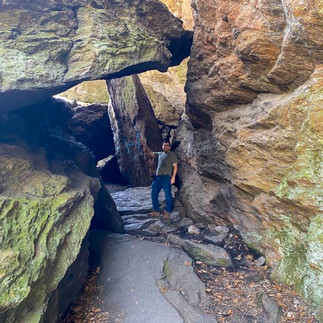
The "Cave" is a fissure cave, it appears to be composed of a large series of boulders that at some point probably broke off from Crane's Lookout above. It is incredibly spacious, at 6' tall I easily stood up with room to spare. It is wide and the trail runs straight through it. The entrance requires you to duck but the exit which is in our photos is huge so you could go around and avoid the crawl. The entrance is in the thumbnail of our video above if you're curious.
Because this out and back was quick, we drove down the road to Nonnewaug Falls. This is a little 1 mile hike, that is mostly just a quick climb up a hill. There are several unmarked side trails and the falls signs aren't hard to miss so many people have complained about getting lost.

You'll arrive at the top of the falls, if you look at my photo in the top left you'll see Nina. That is where you can get to easily. If you want to see the falls from the front you will have to climb down very steep, very loose, dirt. You will get the view pictured to the left. In order to photograph it from the front you will then need to hop across a little bridge of very loose and wobbly rocks in the stream to get to the other shore. Is it worth it? Yes. Honestly this is the most rewarding short hike we've done in a while. It was little effort except for the very end and we had the falls completely to ourselves. There was one group leaving before us and one that came after. It simply isn't well known or popular which is great for us! - and you.

I wouldn't want to come down that final hill in snow and ice but I believe anyone could get down it regularly with enough time. The day we went was the hottest of the week and the falls hadn't received rain in a little while so while they were really nice they do get bigger. The best surprise is that unlike other falls we've been to, there were absolutely no gnats or mosquitos flying around!


Comments